


Voting District 02, Franklin County, North Carolina
About
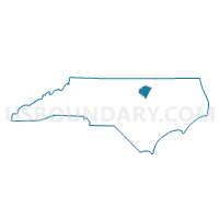
Outline

Summary
| Unique Area Identifier | 640110 |
| Name | Voting District 02 |
| County | Franklin County |
| State | North Carolina |
| Area (square miles) | 21.95 |
| Land Area (square miles) | 21.81 |
| Water Area (square miles) | 0.15 |
| % of Land Area | 99.33 |
| % of Water Area | 0.67 |
| Latitude of the Internal Point | 36.10668890 |
| Longtitude of the Internal Point | -78.31911630 |
Maps


Graphs
Select a template below for downloading or customizing gragh for Voting District 02, Franklin County, North Carolina


Neighbors
Neighoring Voting District (by Name) Neighboring Voting District on the Map
- Voting District 01, Franklin County, NC
- Voting District 05, Franklin County, NC
- Voting District 08, Franklin County, NC
- Voting District 11, Franklin County, NC
- Voting District 12, Franklin County, NC
- Voting District 14, Franklin County, NC
- Voting District 15, Franklin County, NC
- Voting District 16, Franklin County, NC
- Voting District 17, Franklin County, NC
Top 10 Neighboring County Subdivision (by Population) Neighboring County Subdivision on the Map
- Youngsville township, Franklin County, NC (14,423)
- Louisburg township, Franklin County, NC (8,496)
- Harris township, Franklin County, NC (8,327)
- Franklinton township, Franklin County, NC (8,311)
- Cypress Creek township, Franklin County, NC (3,843)
- Sandy Creek township, Franklin County, NC (2,718)
- Hayesville township, Franklin County, NC (2,098)
Top 10 Neighboring Place (by Population) Neighboring Place on the Map
Top 10 Neighboring Unified School District (by Population) Neighboring Unified School District on the Map
Top 10 Neighboring State Legislative District Lower Chamber (by Population) Neighboring State Legislative District Lower Chamber on the Map
Top 10 Neighboring State Legislative District Upper Chamber (by Population) Neighboring State Legislative District Upper Chamber on the Map
Top 10 Neighboring 111th Congressional District (by Population) Neighboring 111th Congressional District on the Map
Top 10 Neighboring Census Tract (by Population) Neighboring Census Tract on the Map
- Census Tract 606, Franklin County, NC (8,582)
- Census Tract 605.02, Franklin County, NC (7,918)
- Census Tract 603.01, Franklin County, NC (5,975)
- Census Tract 604.02, Franklin County, NC (4,944)
- Census Tract 601, Franklin County, NC (4,663)
- Census Tract 603.02, Franklin County, NC (2,563)